Plate Tectonics
The framework that explains the motion of Earth's lithospheric plates and the concentration of geological activity at their boundaries.
- Revision
- 2
- Created by
- SCIENDIA Knowledge Desk
- Updated by
- SCIENDIA Knowledge Desk
- Last updated
- 17.08.2026 18:43
Built by the community
Members can improve this article. Every saved change remains visible in the revision ledger.
Overview
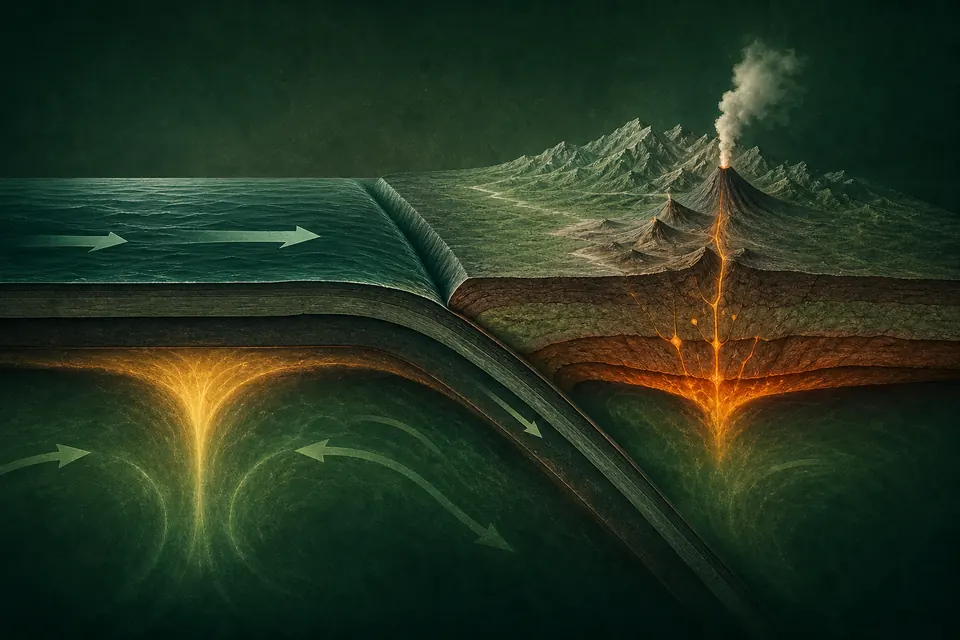
Earth's rigid outer shell is divided into plates that move relative to one another over the weaker asthenosphere. This framework unifies seafloor spreading, subduction, continental drift, mountain building, earthquakes and much volcanic activity.
Technical foundations
The lithosphere behaves as a set of approximately rigid spherical caps moving on a deformable asthenosphere. Plate motion is represented by Euler rotations, so the velocity at any surface point follows from an angular-velocity vector. Oceanic lithosphere cools, thickens and becomes denser with age; negatively buoyant slabs can supply a major component of plate-driving force. Ridge elevation contributes gravitational potential energy, while basal tractions couple plates to mantle circulation. At convergent margins, rheology, hydration and density contrasts determine whether material subducts, accretes or deforms internally.
How it works
New oceanic lithosphere forms at divergent boundaries. At convergent boundaries, dense oceanic lithosphere may descend into the mantle, while collisions can thicken crust and build mountains. Transform boundaries accommodate lateral motion. Plate movement is linked to slab pull, mantle flow and gravitational forces acting on elevated ridges.
Measurement and research methods
Multiple independent observations constrain plate kinematics. Marine magnetic anomalies record polarity reversals symmetrically about spreading centres, ocean-floor ages map lithosphere production, and earthquake focal mechanisms reveal fault orientation and slip sense. Global Navigation Satellite System stations and interferometric radar measure present-day deformation at millimetre-to-centimetre precision. Seismic tomography images velocity anomalies associated with cold slabs and warm upwellings, whereas heat flow, gravity and geochemistry constrain thermal structure and material sources. Reconstructions combine these data with palaeomagnetism and geological piercing points.
Key ideas
- Plate boundaries are zones rather than perfectly sharp geometric lines.
- Ocean basins are continually created, rearranged and recycled.
- Magnetic stripes, earthquake patterns and geodesy independently record plate motion.
Current research frontier
Active research focuses on processes that depart from ideal rigid-plate behaviour. Continental deformation can be distributed across broad zones, slabs may stagnate or tear in the mantle, and subduction initiation remains difficult to observe directly. Thermomechanical simulations couple conservation of mass, momentum and energy with temperature-, pressure- and strain-rate-dependent rheology, but results depend strongly on material parameters. Researchers also examine links among tectonics, erosion, sea level and long-term carbon cycling. Hazard models use plate loading rates and fault geometry probabilistically; the framework does not provide deterministic dates for individual earthquakes or eruptions.
Why it matters
Plate tectonics provides the physical context for natural hazards, long-term climate change, mineral resources and the evolution of continents and oceans. It connects observations from the surface to processes deep inside Earth.
Limits and open questions
The theory predicts large-scale motion well, but many details of plate initiation, mantle coupling and intraplate deformation remain active research topics. It also does not make individual earthquake timing predictable.
Explore through connected concepts
This article is indexed with 20 technical tags. Select a tag to explore the Wiki by concept.
You may also explore
Recommended from the technical tags shared with this article.
Volcanic Eruption Dynamics
The coupled flow, degassing and fragmentation processes that govern how magma reaches the surface and erupts.
Read article →