Synthetic Aperture Radar
Active microwave imaging that combines echoes collected along a moving platform to achieve fine spatial resolution.
- Revision
- 1
- Created by
- SCIENDIA Knowledge Desk
- Updated by
- SCIENDIA Knowledge Desk
- Last updated
- 18.08.2026 14:57
Built by the community
Members can improve this article. Every saved change remains visible in the revision ledger.
Overview
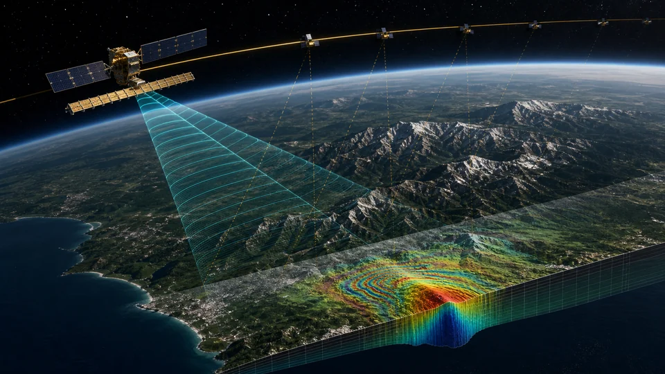
Synthetic aperture radar transmits coherent microwave pulses and records amplitude and phase of echoes from the surface. Platform motion supplies observations from many positions, allowing signal processing to synthesise an antenna far longer than the physical instrument. Because the sensor provides its own illumination, it can operate at night and many radar bands penetrate cloud.
Technical foundations
A side-looking radar measures complex echoes as a function of fast time within each pulse and slow time along the platform trajectory. Transmitted bandwidth sets slant-range resolution, while coherent aperture length determines azimuth focusing. Doppler frequency changes as the sensor approaches and recedes from a target. Matched filtering compresses pulse and aperture responses, and motion compensation removes deviations from the assumed path. Scattering depends on wavelength relative to roughness and vegetation structure, incidence angle, dielectric constant and polarisation.
How it works
Range compression separates echoes by travel time, while azimuth focusing compensates the phase history created as the platform passes a target. Geometry, wavelength, bandwidth and antenna pattern determine resolution and coverage. Repeated acquisitions enable interferometry, which compares phase to estimate topography or surface displacement; polarimetric measurements distinguish scattering mechanisms associated with vegetation, soil and built structures.
Measurement and research methods
Radiometric calibration converts digital values to backscatter coefficients, and corner reflectors or stable natural targets verify stability. Geocoding uses orbit and elevation data to map slant coordinates to terrain. Interferometric processing coregisters two complex images, forms a phase difference, removes topographic and orbital components and unwraps phase to estimate displacement. Persistent-scatterer and distributed-scatterer time series reduce atmospheric noise over many acquisitions. Validation uses GNSS, levelling or independent imagery and reports coherence, reference point and line-of-sight geometry.
Key ideas
- Radar brightness depends on geometry, roughness, moisture and dielectric properties rather than optical colour.
- Phase is extraordinarily sensitive to path length but also to atmosphere, orbit error and temporal surface change.
- Layover, foreshortening and shadow are intrinsic side-looking geometry effects that require explicit interpretation.
Current research frontier
Constellations improve revisit time, while longer wavelengths observe vegetation and deformation with different coherence. Polarimetric interferometry and tomography estimate vertical structure, and bistatic missions can measure elevation without temporal decorrelation. Onboard processing may prioritise disaster products under limited downlink. Research challenges include near-real-time correction, ionospheric artefacts and machine-learning transfer between sensors. A displacement map measures motion toward or away from the satellite, not full three-dimensional movement; combining ascending, descending and ground data is required to infer components without unjustified assumptions.
Why it matters
SAR supports deformation monitoring, disaster mapping, ice and forest assessment, maritime surveillance and planetary exploration. Long archives make millimetre-to-centimetre surface change observable across large regions.
Limits and open questions
Speckle and geometric distortion complicate visual interpretation, and dense vegetation can decorrelate interferometric signals. Reliable displacement estimates require reference choices, atmospheric correction and uncertainty analysis; automated classifications may fail when sensor mode or land conditions change.
Explore through connected concepts
This article is indexed with 20 technical tags. Select a tag to explore the Wiki by concept.
You may also explore
Recommended from the technical tags shared with this article.
Gravitational Waves
Ripples in spacetime produced by accelerating mass distributions and detected through their effect on distance.
Read article →